Project Categories

Home    Projects   Coastal Engineering    Shoreline Process

Shoreline Process

Shoreline Evolution, Sand Volume Change, and Shoreline Retreat or Advance

Listed below are many of the projects we’ve completed for our clients over the years. We’ve chosen to focus and expand on several key examples which are highlighted in blue. Clicking on those projects allows you to view in-depth what services NCI provided as well as details on the project itself.

California Coastal Storm & Tidal Wave Study

Orange County, CA

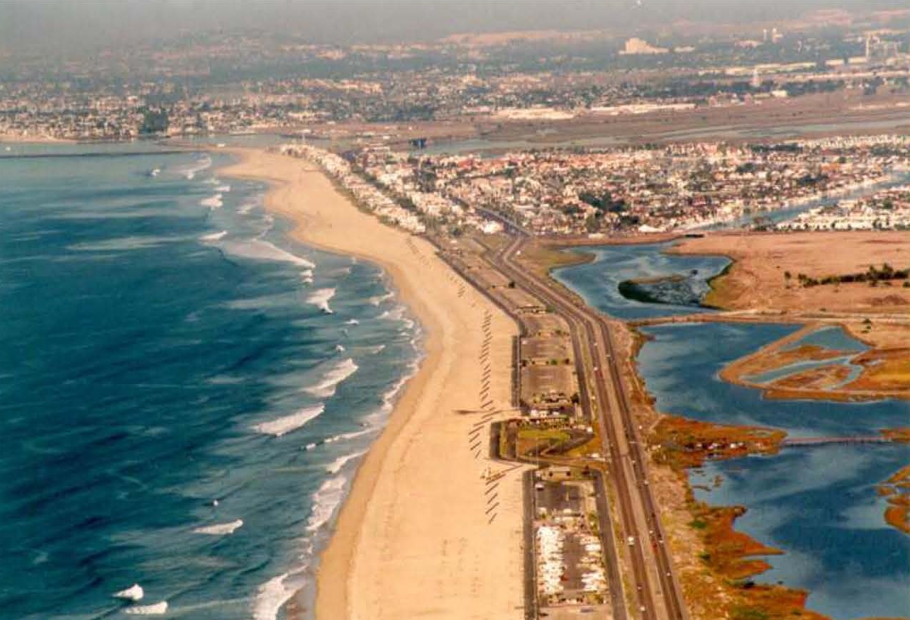
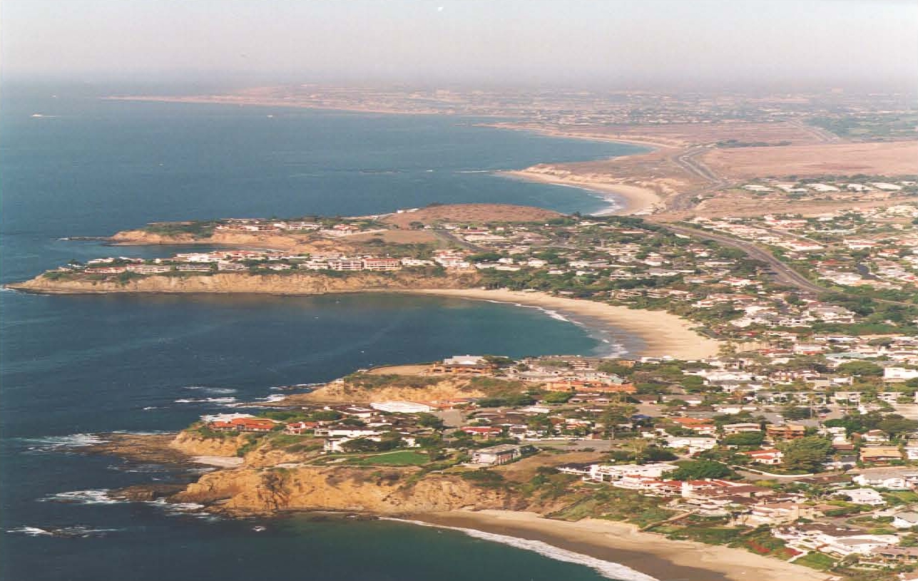
In support of the U.S. Army Corp of Engineers’ Coast of California Storm and Tidal Waves Study, NCI conducted a comprehensive analysis to define the prevailing and extreme near-shore wave climate along 30 miles of metropolitan shoreline. The purpose of the study was to provide input for sand management planning and to better define design criteria for shoreline stabilization structures and development. Local, regional and global meteorology was studied to identify the dominant patterns of deep-water wave generation. Near-shore transformation of wave energy along the study area was described using a state-of-the-art spectral refraction model, which included island-sheltering effects. The analysis was synthesized into recurrence estimates of expected wave conditions throughout the County’s shoreline using a Monte Carlo simulation. The numerical model simulated the seasonal variation in deep-water wave occurrences and the resultant heights, periods, and angles of incidence after propagation to the Orange County coastline. Extreme wave climate was determined using a storm track hind-cast technique.


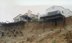
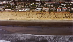
The numerically simulated near-shore wave climate was used to estimate the annual alongshore transport rate within the study reaches. In addition, a flooding analysis induced by impinging waves and high tides during storm events of various return frequencies was conducted. A regional sand management plan was then formulated, based upon the long-term coastal processes assessment, the projected sediment budget, and the analyzed short-term flooding scenarios. The sand management plan consisted of three objective elements of long-term beach preservation, short-term storm protection and regular monitoring. Progressive levels of action were formulated for each element to accomplish a series of successive and sequential steps for different phases of management goals.


California Coastal Storm & Tidal Wave Study California Coastal Storm & Tidal Wave Study

Encinitas/Solana Beach Shoreline Study

San Diego County, CA

NCI prepared the Section 905(b) analysis to determine the viability of providing shore protection and environmental restoration, and the Project Management Plan to itemize the various tasks and schedules of the feasibility phase study along the coastline of the Cities of Encinitas and Solana Beach including a coastal wetland area, the San Elijo Lagoon. The planning objectives of the study included the reduction of coastal storm-related damage while improving the hazardous conditions caused by episodic bluff failure, increasing the recreational values of the region by improving area beaches, maintaining the Old Highway 101 corridor during storm events, and the enhancement of the ecological and hydrologic system within the San Elijo Lagoon and adjacent beaches.


NCI is currently conducting a feasibility-level evaluation of storm damage and bluff erosion potential within the Encinitas/Solana Beach shoreline. The Cities’ 7.9-mile shoreline was investigated in detail to assess storm damage potential associated with shoreline erosion, seacliff retreat, and wave related folding of sandy and cobble beach areas. A without-project-condition (F3) study report was completed in February 2003. The scope of study included a comprehensive geotechnical evaluation of marine related and sub-aerial bluff erosion processes, a coastal engineering analysis to summarize relevant oceanographical and sediment transport conditions, and prediction of future damages to property and infrastructure under the consideration of federal interest involvement. Episodic bluff failure was modeled through a combined Monte Carlo simulation that includes characteristics of the bluff’s geologic make-up and the randomness of wave climate within this region. Based upon the findings of the modeled bluff failure scenarios, various engineering alternatives (F4) to reduce storm damage and prevent bluff failure are being formulated. Proposed plan alternatives will be evaluated in terms of engineering, economic and environmental merits. The potential measures that are being investigated include beach nourishment with or without sand retention structures, innovative cobble berm construction, and various seawall and revetment scenarios, etc. This study also incorporates the Geographic Information System (GIS) to integrate all collected historic field data and to-be-conducted field survey so that local governments can continuously update the GIS database.


Encinitas/Solana Beach Shoreline Study Encinitas/Solana Beach Shoreline Study

Omaha Beach Nourishment

Omaha Beach, New Zealand

Based upon an intensive investigation of the coastal processes along a sand spit and inlet at Omaha Beach, NCI participated in the design of a series of groins, a seawall and a program of beach nourishment to reestablish shoreline equilibrium as a means of shore protection, stabilization of a navigational channel and protection of waterfront homes. Services included the preparation of engineering drawings, specifications and cost estimates, in addition to construction review and a follow-up beach monitoring program.


Omaha Beach Nourishment

Comprehensive Coastal Sand Management Plan

Santa Barbara/Ventura County Coastline, CA

B.E.A.C.O.N. is a joint power authority consisting of the Cities of Port Hueneme, Oxnard, San Buenaventura, Carpinteria and Santa Barbara, and the Counties of Ventura and Santa Barbara, which was established to seek solutions to reestablish their eroding shorelines. NCI’s study included the inventory of offshore, harbor entrance and fluvial sand sources; estimating erosion rates and sediment budgets; preparing a comprehensive sand management program to control beach erosion; and recommending and implementing an effective monitoring plan to observe indicators of beach health within the Santa Barbara and Ventura County coastline. A field program of seismic profiling, dart coring and vibracore sampling was performed to identify favorable sand deposits that exist within close proximity to beaches in need of nourishment. The flood levels and erosion rates/sediment budget were developed using numerical wave and sediment models, aerial photographs and surveyed beach profiles. Twenty-five beach profile stations covering the 60-mile study coastline were established, with two sets of bathymetric surveys performed along these transects. This study included evaluating potential dredging equipment, and methods and costs to perform large scale beach nourishment. Environmental, economic and cost-benefit evaluations were also performed. The final report recommended three alternative levels of a coastal sand management plan and included several demonstration projects. Funding opportunities are being explored through federal and state channels.


Comprehensive Coastal Sand Management Plan
© 2024 Noble Consultants, Inc.